
Typhoon Jangmi: The Storm That Put Japan on
Alert
June 2026
————————————————————————
When Tropical Storm Jangmi formed over the western Pacific on May 28, 2026, it appeared, at first glance, like many of the early-season systems that spin up in those warm equatorial waters and then quietly fade. It did not fade. Over the following week, Jangmi slowly but relentlessly tracked north-northwest across the Philippine Sea, intensifying into a full typhoon, carving a wide path of destruction across southern Japan, and setting an ominous tone for what forecasters are already warning will be one of the most punishing typhoon seasons in modern Japan.
————————————————————————
Birth of a Storm
Jangmi — the name means “rose” in Korean, a name contributed to the World Meteorological Organization’s rotating list by South Korea — began its life as a tropical depression before being classified as a tropical storm on May 28. Within 48 hours, it had strengthened into a typhoon, feeding on the unusually warm sea surface temperatures of the Philippine Sea. Its slow movement was immediately flagged by meteorologists as a serious concern: the slower a storm moves, the longer it lingers over any given area, and the more rain it dumps.
By May 30, the Joint Typhoon Warning Center (JTWC) reported sustained winds of 120 kilometres (75 miles) per hour — equivalent to a Category 1 hurricane on the Saffir-Simpson scale. A day later, winds had climbed to 130 kilometres (80 miles) per hour as Jangmi crept toward Okinawa. At its peak, the storm registered sustained winds of 85 miles per hour with gusts reaching 105 miles per hour, according to AccuWeather tracking data.
————————————————————————

A Giant Eye Seen From Space
One of the most striking features of Typhoon Jangmi was not the destruction it caused on the ground, but the spectacle it presented from orbit. NASA’s VIIRS (Visible Infrared Imaging Radiometer Suite) instrument aboard the Suomi NPP satellite captured a dramatic nighttime image of the storm at 1:40 a.m. Japan Standard Time on May 31 — a photograph that quickly circulated across scientific and news outlets worldwide.
The image revealed a large, clearly defined eye at the storm’s centre. Scott Braun, a research meteorologist at NASA’s Goddard Space Flight Center, noted that the eye’s diameter was “on the larger end of the spectrum” compared with many tropical cyclones. The satellite image also showed mesocyclones — rotating sub-structures within the eyewall — partially visible beneath higher cloud layers. Braun described these as visually impressive but meteorologically normal features within a mature typhoon. A second image, acquired the following day by the VIIRS instrument aboard the NOAA-20 satellite, showed the storm had intensified slightly and was now bearing directly toward Okinawa, with its outer cloud bands already stretching over land.
————————————————————————
Japan Takes the Hit
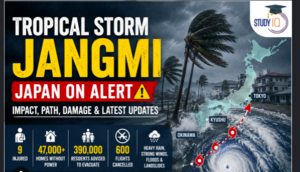
Jangmi made its presence felt on land beginning June 2–3, 2026, when it swept past Okinawa and bore down on Kyushu, Shikoku, and the Pacific coast of Honshu before eventually turning northeast. The Japan Meteorological Agency classified it as Typhoon No. 6 and issued some of its highest-tier alerts across multiple prefectures. Wakayama Prefecture received a Level 5 warning — the most severe category in Japan’s alert system, reserved for situations where catastrophic damage is considered imminent. Tokyo and surrounding prefectures were placed on Level 4 flood danger warnings, urging immediate evacuation of low-lying communities.
At least 16 people were injured as the typhoon passed through Okinawa and Kagoshima prefectures, where a utility worker was among the casualties. Nearly 48,000 households in those two prefectures were left without electricity as the storm tore through power infrastructure. In Okinawa alone, the airport was shut down entirely, with a departures board at Tokyo’s Haneda Airport showing a wall of cancellations for flights to the island.
By the time Jangmi crossed into mainland Japan, the transportation chaos was nationwide in scale. Nearly 900 domestic and international flights were cancelled, stranding tens of thousands of passengers at major airports including Tokyo, Osaka, and Nagoya. Shinkansen bullet train services were suspended across multiple lines — a disruption that, in Japan, signals a weather event of genuine severity, since the rail network is engineered to operate through most storms. Local metro services in several cities were also halted. Hotels near capacity during Japan’s spring travel season struggled to accommodate stranded travellers, and airlines faced days of cascading delays trying to rebook passengers.
Flood-related alerts were issued for rivers across a broad stretch of the Pacific coast. The storm’s slow movement — the very characteristic that made it so dangerous — meant that even after the eye had passed, the outer rain bands continued to drench communities for hours. Landslide warnings were issued across mountainous prefectures where saturated soil on steep slopes posed a persistent threat to villages below.
————————————————————————
A Warning for the Season Ahead
Jangmi is not an anomaly — it is a preview. Japan’s meteorological agencies have forecast up to 28 tropical storms forming in the western North Pacific in 2026, against a long-term average of 25.1. More alarming, as many as 14 storms are expected to make landfall on Japan’s main islands — a figure that dwarfs the historical average of fewer than three per year. By the end of May, six typhoons had already formed, running well ahead of the seasonal norm, when most storms typically develop between July and October.
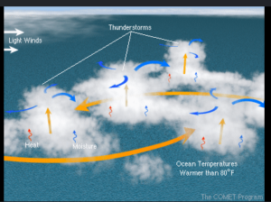
The underlying driver is well-documented: warming sea surface temperatures in the western Pacific are creating a more energetic and extended breeding ground for tropical cyclones. Climate scientists have noted that warmer oceans not only produce more storms, but tend to produce storms that intensify more rapidly and carry greater quantities of moisture — meaning more extreme rainfall even from storms that do not reach the highest wind speeds. Jangmi, with its slow crawl and expansive rain bands, is precisely the kind of storm that climatologists have been warning about for years.
For Japan — a country that already invests more in disaster preparedness than almost anywhere else on Earth, with typhoon-resistant construction codes, sophisticated early-warning systems, and highly trained emergency response agencies — Jangmi exposed the limits of infrastructure designed for a different climate baseline. The disruption to transportation and tourism during what should have been a busy spring travel window was significant. Economically, the losses in cancelled flights, halted commerce, and infrastructure repair will take weeks to fully calculate.
For now, authorities and meteorologists are watching the western Pacific closely. If forecasters are right, the storm that swept Okinawa’s airport clean and darkened 48,000 homes in early June is just the first rose of a long and thorny season.
Jangmi is not an anomaly — it is a preview. Japan’s meteorological agencies have forecast up to 28 tropical storms forming in the western North Pacific in 2026, against a long-term average of 25.1. More alarming, as many as 14 storms are expected to make landfall on Japan’s main islands — a figure that dwarfs the historical average of fewer than three per year. By the end of May, six typhoons had already formed, running well ahead of the seasonal norm, when most storms typically develop between July and October.
The underlying driver is well-documented: warming sea surface temperatures in the western Pacific are creating a more energetic and extended breeding ground for tropical cyclones. Climate scientists have noted that warmer oceans not only produce more storms, but tend to produce storms that intensify more rapidly and carry greater quantities of moisture — meaning more extreme rainfall even from storms that do not reach the highest wind speeds. Jangmi, with its slow crawl and expansive rain bands, is precisely the kind of storm that climatologists have been warning about for years.
For Japan — a country that already invests more in disaster preparedness than almost anywhere else on Earth, with typhoon-resistant construction codes, sophisticated early-warning systems, and highly trained emergency response agencies — Jangmi exposed the limits of infrastructure designed for a different climate baseline. The disruption to transportation and tourism during what should have been a busy spring travel window was significant. Economically, the losses in cancelled flights, halted commerce, and infrastructure repair will take weeks to fully calculate.
For now, authorities and meteorologists are watching the western Pacific closely. If forecasters are right, the storm that swept Okinawa’s airport clean and darkened 48,000 homes in early June is just the first rose of a long and thorny season.